
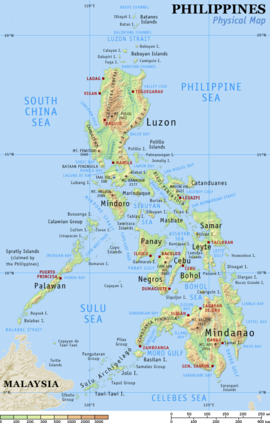
Terrain
The islands are volcanic in origin, being part of the Pacific Ring of Fire, and are mostly mountainous. The highest point in the country is the peak of Mount Apo in Mindanao, which is 2,954 meters (9,692 ft) above sea level. The second highest point can be found on Luzon at Mount Pulog, a peak 2,842 meters (9,324 ft) above sea level.
The Philippine Archipelago is geologically part of the Philippine Mobile Belt located between the Philippine Sea Plate, the South China Sea Basin of the Eurasian Plate, and the Sunda Plate. The Philippine Trench (also called the Mindanao Trench) is a submarine trench 1,320 kilometers (820 mi) in length found directly east of the Philippine Mobile Belt and is the result of a collision of tectonic plates. The Philippine Sea Plate is subducting under the Philippine Mobile Belt at the rate of about 16 centimeters (6.3 in) per year. Its deepest point, the Galathea Depth, has a depth of 10,540 meters (34,580 ft). The Philippine Fault Systemconsists of a series of seismic faults that produce several earthquakes per year, most of which are not felt.
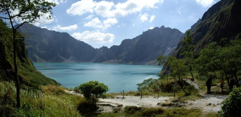
Many volcanoes in the country are active, the most recent eruption being that of Mount Pinatubo on Luzon in 1991. Mount Mayon is another of the active volcanoes and has the world’s most perfectly-shaped cone. Mayon has a violent history of 47 eruptions since 1616 and another violent eruption is currently feared. Taal Volcano, also located on Luzon, is one of the Decade Volcanoes.
The islands typically have narrow coastal plains and numerous swift-running streams. Every island has sand beaches, but few open onto spacious lowlands. There are few large plains or navigable rivers. The longest river is the Cagayan River or Rio Grande de Cagayan in northern Luzon measuring 354 kilometers. In Mindanao, the longest river is the Rio Grande de Mindanao or Mindanao River which drains Maguindanao and other parts in western-central Mindanao. Agusan River drains eastern Mindanao.
Eco-regions of the Philippines
The Philippine archipelago is one of the world’s great reservoirs of biodiversity and endemism. The archipelago includes over 7000 islands, and a total land area of 300,780 km².

The Philippines was never connected to mainland Asia via land bridges, so the flora and fauna of the islands had to cross ocean straits to reach the Philippines. The Philippines is part of the Indomalaya ecozone, and its flora and fauna is mostly derived from tropical Asia. Botanically, the Philippines are part of Malesia, a floristic province that includes the Malay Peninsula, Indonesia, and New Guinea. Most of the Malesian flora is derived from tropical Asia, including the dipterocarps, which are the characteristic tree of the Philippine forests. Elements of the Antarctic flora, which originated in the ancient southern hemisphere supercontinent of Gondwana, are also present, including ancient conifers like podocarps (Podocarpus, Na
The ecoregions of the Philippines are defined primarily by the sea levels during the Ice Ages, which were 120 meters lower than at present, as billions of gallons of water were locked away in huge continental ice sheets. This drop in sea level connected many presently separate islands into larger islands, which allowed for exchanges of flora and fauna:
- Greater Luzon included Luzon, Catanduanes, Marinduque, Polillo, and several small islands.
- Greater Mindanao included Mindanao, Ba
silan, Bohol, Leyte, Samar, and adjacent small islands. - Greater Palawan included Palawan, Balabac, Busuanga, Culion, Cuyo, and adjacent small islands.
- Greater Negros-Panay included Negros,
Panay, Cebu, and Masbate. - Greater Sulu included the most of the Sulu Archipelago, from Tawi Tawi to Jolo.
These formerly linked islands each constitute a separate ecoregion, as does Mindoro, which remained separate from the rest, along with a few smaller islands, notably Camiguin, Sibuyan, and Siquijor.
Each group of islands that were linked by land bridges in the ice ages also constitutes a separate faunal region. The lack of a land bridge to the Asian continent prevented most of the Asian megafauna, including elephants, rhinocero
The other main factor that defines the Philippine ecoregions is elevation; the high mountains of Luzon and Mindanao host distinct montane rain forest ecoregions. The mountains of Luzon are also home to the Luzon Tropical Pine Forests
Articles from Wikipedia
http://en.wikipedia.org/wiki/Geography_of_the_Philippines
http://en.wikipedia.org/wiki/Ecoregions_in_the_Philippines
(Re-produced under fair-use and with credit)